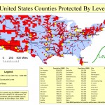
We thought this information so important that we commissioned a researcher to translate the volume of data tables into a easy-to-read map.
The result is eye popping.
The graphic and accompanying table shows that living in counties protected by levees is not a distinctly New Orleans phenomenon. Nor is it even a coastal issue. Nor a sea level issue.
And the map raises very important questions.
After the federal flood, the nation questioned the wisdom of further public investment in levees and other flood risk reduction infrastructure in New Orleans and south Louisiana.
This map sheds a whole lot of light and insight on the benefits of using levees and other control structures to settle floodplains.


One has to ask: Would the issue of whether to rebuild have been raised had Katrina hit southern California and done as much damage rather than New Orleans???
[…] the United States is protected by levee systems. A North Dakota town is now nearly submerged because of its lack of protection from flooding […]