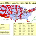
In April 2009, Levees.org filed a request to FEMA under the Freedom of Information Act (FOIA). We wanted to know where the people lived who were protected by levees.
Six months later, FEMA responded and we learned that the majority (55%) of the American people lives in counties protected by levees.
Researcher Ezra Boyd converted the mountain of data into an easy-to-read map (see above). Shortly afterward, Levees.org commissioned Boyd to create a white paper analyzing the data.
The results were then published by the New Orleans Times Picayune, Homeland Security, the American Society of Civil Engineers, and the Insurance Journal.
And Levees.org just heard that Boyd’s white paper entitled “Assessing the Benefits of Levees: An Economic Assessment of U.S. Counties with Levees” has been accepted for Challenges of Natural Resource Economics & Policy: The Third National Forum on Socioeconomic Research in Coastal Systems.
The CNREP 2010 conference will be held in New Orleans LA on May 26-28, 2010.


Yay!
Congratulations Ezra and Levees.org!
That paper is such a good solid piece of work. And as well, the results remain incontrovertible and unassailed in any of the comments sections I’ve seen on the paper. Some may offer their opinion, but none have been able to dispute Ezra’s findings from the data presented.
Plus, everyone is just Jealous As Hell of that Map!
We hope Y’all make a Poster of it.
I’ll hang it on my living room wall, right next to the one I have that your son made “Together We Can Rebuild”.
Levees.org: Artifacts Not Politics.
Thanks again, Y’all.